
You have your drone charged up, propellers mounted, and the perfect shot planned. But the moment you try to take off, your controller flashes a warning and the motors refuse to spin. If this has happened to you, you are not alone. Thousands of drone pilots experience this frustration every single day.
When you wonder why does my drone refuse to fly in certain locations, the answer almost always comes down to one thing: geofencing. This GPS-based restriction system was designed to keep drones out of sensitive airspace near airports, government facilities, military bases, and other restricted areas. But for many pilots, especially those living near these zones, geofencing feels like an invisible wall around their own property.
The landscape shifted dramatically in January 2025 when DJI, the world’s largest drone manufacturer, removed all built-in geofencing from its aircraft. This change fundamentally altered how drone restrictions work and shifted the responsibility for safe, legal flying entirely onto the pilot. Many drone owners still do not fully understand what this means for them.
In this guide, I will walk you through everything you need to know about drone flight restrictions in 2026. We will cover how geofencing works, the different types of restricted zones, FAA regulations you must follow, how to check your airspace before flying, and what to do when your drone still refuses to take off. Whether you fly a DJI Mini, Air, Mavic, or any other brand, this information will help you get back in the air legally and safely.
Table of Contents
What Is Drone Geofencing and How Does It Work?
Drone geofencing is a software-based system that uses GPS coordinates to create virtual boundaries around restricted areas. When your drone detects that it is inside one of these boundaries, the flight controller either prevents the motors from starting or limits your ability to fly in that zone.
Think of it as an invisible fence built into your drone’s software. The system constantly compares your GPS location against a database of restricted zones maintained by the manufacturer. If you are standing inside a restricted area, the drone simply will not take off, no matter how many times you press the launch button.
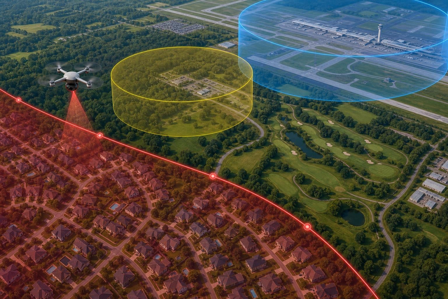
For DJI drones specifically, this system was called the Geospatial Environment Online (GEO) system. It used color-coded zones to indicate different levels of restriction. Red zones completely blocked flight, while yellow zones displayed warnings but still allowed takeoff. The system pulled data from aviation authorities worldwide to keep its restriction maps current.
The geofencing system communicates with your drone through firmware updates and the companion app, such as the DJI Fly app. When you connect your controller and the app detects your location, it checks the GEO database and applies any relevant restrictions before allowing you to fly.
Other manufacturers implemented similar systems. Autel Robotics, Skydio, and Parrot all built their own versions of geofencing into their drones to comply with aviation regulations and reduce the risk of unauthorized flights near sensitive locations.
The Big Change: DJI Removed All Geofencing in January 2025
On January 13, 2025, DJI made a move that sent shockwaves through the drone community. The company announced it was removing all geofencing restrictions from its consumer and enterprise drones worldwide. This was arguably the most significant policy change in the consumer drone industry’s history.
What this means in practical terms is that DJI drones no longer automatically prevent you from flying in restricted areas. The old color-coded GEO zones that blocked takeoff near airports, military bases, and government facilities have been replaced with informational advisories. Your DJI drone will now show you a warning on screen, but it will not stop you from taking off.
DJI framed this decision as aligning with how aviation authorities actually manage airspace. The company argued that aviation regulators, not drone manufacturers, should be the ones enforcing airspace rules. They pointed out that traditional aviation has never had manufacturer-imposed geofencing, and pilots are expected to know and follow the rules on their own.
For drone pilots, this change is a double-edged sword. On one hand, you no longer have an artificial barrier preventing you from flying on your own property near an airport. On the other hand, you are now fully responsible for knowing whether you are legally allowed to fly in any given location. Fly somewhere you should not, and you alone face the consequences.
The removal also created confusion. Many pilots who purchased drones before 2025 still expected geofencing to block them. Some have reported that their drones still refuse to fly in certain spots, which usually points to outdated firmware or other technical issues we will cover later in this guide.
If you bought a DJI drone in 2026 and expected it to block you from flying in restricted areas, you need to understand that this safety net no longer exists. You must check airspace restrictions yourself before every single flight.
Types of Restricted Zones: Red, Blue, Yellow, and Gray Explained
Even though DJI removed its geofencing system, understanding the old color-coded zone classifications remains valuable. These categories mirror real FAA airspace classes, and many drone apps still use similar color schemes to display restrictions. Here is what each zone type meant and how it relates to current airspace rules.
Red Zones: No Flying Under Any Circumstances
Red zones represented the strictest restrictions in DJI’s old system. These covered active runways, military installations, and other areas where drone flight posed an immediate safety risk. In these areas, the drone would not take off at all without a special unlocking authorization from DJI. Under current FAA rules, these areas typically correspond to the innermost rings of controlled airspace around major airports and prohibited areas like military bases.
Blue Zones: Authorization Required
Blue zones required you to get authorization before flying. In the United States, this meant obtaining LAANC (Low Altitude Authorization and Notification Capability) approval from the FAA. This system allows drone pilots to request near-real-time authorization to fly in controlled airspace near airports. If you had LAANC approval, you could unlock the blue zone and fly legally within your approved parameters.
Yellow Zones: Advisory Warnings
Yellow zones, also called Enhanced Warning Zones, displayed a caution message but did not prevent flight. These areas typically sat at the outer edges of controlled airspace or near locations with some level of concern. Pilots could acknowledge the warning and proceed with takeoff. The old system trusted pilots to use judgment in these zones.
Gray Zones: Self-Unlock Required
Gray zones required a Self Unlock through the DJI Fly app or DJI website. You would enter your flight controller serial number and request unlocking for a specific location and time period. Unlike blue zones, gray zones did not require external authorization from the FAA. They were often tied to large events, temporary flight restrictions, or areas where DJI had placed additional caution beyond regulatory requirements.
Now that DJI has removed geofencing, these zones function as informational overlays rather than hard blocks. However, the underlying FAA airspace classes remain in effect. Flying in controlled airspace without LAANC authorization is still illegal regardless of what your drone allows you to do.
FAA Regulations and Airspace Restrictions
The FAA governs all airspace in the United States, and every drone pilot must comply with their rules. Whether you fly for fun or for money, the same airspace classifications apply to you. Understanding these classifications is the foundation of knowing where you can and cannot fly.
Airspace in the US is divided into classes labeled A through G. For drone pilots, the most relevant are Class B, C, D, and E, which surround airports and require authorization to enter. Class G airspace is uncontrolled and generally does not require authorization for drone flights below 400 feet.
Class B airspace surrounds the nation’s busiest airports. Think major hubs like JFK, LAX, and O’Hare. Class C covers medium-sized airports with control towers and radar service. Class D wraps around smaller airports with control towers. Class E is controlled airspace that does not fit the other categories. In all of these classes, you need LAANC authorization to fly a drone.
Beyond airspace classes, the FAA also issues Temporary Flight Restrictions (TFRs) that can change daily. These might cover sporting events, wildfire areas, presidential movements, or disaster zones. A location that was perfectly fine to fly yesterday might be completely off-limits today because of an active TFR.
If you fly under Part 107 rules for commercial operations, you have specific requirements including passing the Part 107 knowledge test, registering your drone, and maintaining visual line of sight. Recreational flyers operate under The Exception for Limited Recreational Operations of Unmanned Aircraft, which has its own set of requirements including passing the TRUST test.
Since September 2023, the FAA also requires all drones weighing more than 0.55 pounds (250 grams) to comply with Remote ID rules. Remote ID functions like a digital license plate for your drone, broadcasting identification and location information. If your drone does not meet Remote ID requirements, you are flying illegally.
How to Check If Your Location Is Restricted Before Flying
Checking your airspace before flying should become as automatic as checking your battery level. With DJI’s geofencing gone, this step is more important than ever. Here is a step-by-step process I recommend for every flight.
Step 1: Use the FAA B4UFLY app. This free app from the FAA is the official tool for checking recreational drone restrictions. It shows controlled airspace, TFRs, national parks, military areas, and other restrictions around your current location. The interface is straightforward and color-coded for quick reference.
Step 2: Check LAANC availability with Aloft. Formerly known as AirMap, Aloft is the leading app for LAANC authorization. It shows you which controlled airspace areas have LAANC available and lets you request authorization directly from your phone. This is essential if you are near an airport and need near-real-time approval.
Step 3: Review the DJI Fly app map. Even with geofencing removed, the DJI Fly app still displays advisory information about your surroundings. The map view shows nearby airports, restricted areas, and any active warnings. It will not block you from flying, but it will inform you about potential concerns.
Step 4: Check for active TFRs. Visit the FAA TFR website or use an aviation app like ForeFlight to check for temporary restrictions. TFRs can pop up with little notice for events, VIP movements, or emergency situations. Flying into an active TFR can result in serious penalties.
Step 5: Verify local restrictions. National parks, state parks, city parks, and private property all have their own rules. Some cities have banned drone takeoffs and landings within their boundaries. Check local ordinances before flying in any unfamiliar area.
I recommend building this checklist into your pre-flight routine. It takes about five minutes and can save you from fines that reach thousands of dollars. The FAA has been increasing enforcement efforts, and ignorance of restrictions is not a valid defense.
Getting Authorization: How to Legally Fly in Controlled Airspace
If you discover that your planned flight location is in controlled airspace, you are not out of luck. The LAANC system makes it possible to get authorization in near-real-time, often in less than a minute. Here is how the process works.
LAANC stands for Low Altitude Authorization and Notification Capability. It is a partnership between the FAA and private companies that provides drone pilots with a streamlined way to request and receive airspace authorization. The system covers hundreds of airports across the United States and processes thousands of authorizations daily.
To use LAANC, you need a compatible app like Aloft, AirHub, or DroneUp. Open the app, select the grid where you want to fly, and choose your maximum altitude. The app sends your request to the FAA, and most approvals come back within seconds. You will receive a confirmation with your authorization details, which you should keep on your phone during the flight.
LAANC authorizations specify a maximum altitude, usually between 0 and 400 feet. In some grids near busy airports, you might only be approved for very low altitudes or not at all. The system accounts for real-time air traffic, so if the control tower is especially busy, your request might be denied.
For commercial pilots flying under Part 107, LAANC is available for operations in most controlled airspace. Recreational pilots can also use LAANC, but some additional restrictions may apply depending on the airspace class and the airport.
If LAANC is not available at your location, you can request authorization through the FAA DroneZone website. This process takes longer, usually several days to weeks, so plan well ahead. The DroneZone also handles requests for waivers to fly at night, beyond visual line of sight, or over people.
Why Your Drone Still Won’t Take Off (Even After the DJI Policy Change)
Even after DJI removed geofencing in January 2025, many pilots still find their drones refusing to fly. This can be incredibly frustrating, especially when you are standing in a legal flying area and your aircraft still will not cooperate. Here are the most common reasons your drone might still be grounded.
Outdated Firmware Still Enforcing Old Restrictions
If you have not updated your drone’s firmware since before January 2025, the old geofencing restrictions might still be active on your aircraft. DJI rolled out the geofencing removal through firmware updates, meaning you must install the latest firmware to benefit from the policy change. Check the DJI Fly app for available updates and install them before your next flight.
GPS Signal Issues Mimicking Geofencing
A weak or nonexistent GPS signal can cause symptoms that look exactly like geofencing. Your drone needs a minimum number of GPS satellites locked before it will allow takeoff, typically at least 8 to 12 satellites. If you are flying indoors, in a canyon, near tall buildings, or under heavy tree cover, GPS reception can be poor enough to prevent startup. Try moving to an open area with clear sky visibility.
Compass Calibration Problems
A poorly calibrated compass can prevent takeoff even when GPS is strong. If your drone detects a discrepancy between its compass and GPS heading, it may refuse to fly as a safety measure. The DJI Fly app will usually display a compass error prompt. Recalibrate your compass by following the on-screen instructions, typically done by rotating the drone in specific patterns.
Software Bugs and App Glitches
Sometimes the problem is not with your drone at all but with the control app. The DJI Fly app, like any software, can experience bugs that prevent normal operation. Force-close the app, restart your controller and drone, and try again. If the issue persists, try reinstalling the app or using a different device.
Other Manufacturer Geofencing Still Active
If you fly a drone from Autel, Skydio, Parrot, or another manufacturer, geofencing may still be in place. Not all companies followed DJI’s lead in removing restrictions. Check your manufacturer’s support documentation for their current geofencing policy and unlocking procedures.
Hardware Failures
In rare cases, a hardware problem with your drone’s GPS module, compass, or flight controller could prevent takeoff. If you have ruled out all software and environmental causes, contact the manufacturer’s support team for diagnosis. Continuing to fly a drone with hardware issues is dangerous.
State and Local Drone Restrictions You Need to Know
The FAA controls all airspace in the United States, but state and local governments can still restrict where you take off and land your drone. This creates a complex patchwork of rules that varies from place to place.
National Parks have a blanket ban on all drone operations, including takeoff, landing, and flight within park boundaries. This rule is enforced by the National Park Service and carries significant penalties. State and local parks often have their own drone restrictions, which vary widely.
Many cities have passed ordinances banning drone flights in public spaces or requiring permits for drone operations. Universities, sports stadiums, and large public venues often have temporary restrictions during events. The FAA’s stadium TFR prohibits drone flights within 3 nautical miles of any stadium hosting a MLB, NFL, or NCAA Division I football game with 30,000 or more attendees, from one hour before to one hour after the event.
Always research local regulations before flying in any unfamiliar area. Local law enforcement may not understand FAA airspace rules, but they do enforce local ordinances about parks, privacy, and nuisance. Carrying a copy of your Part 107 certificate or TRUST completion and knowing your rights can help avoid confrontations.
FAQs
Did DJI disable geofencing?
Yes. On January 13, 2025, DJI removed all built-in geofencing restrictions from its consumer and enterprise drones. The old color-coded GEO zones have been replaced with informational advisories only. Your DJI drone will no longer prevent takeoff in restricted areas, but it will display warnings. This means you are now fully responsible for verifying that your flight location is legal before every flight.
How to disable flight restrictions on DJI?
After DJI’s January 2025 policy change, geofencing restrictions were removed through firmware updates, so you no longer need to disable them manually. Simply update your drone to the latest firmware. If your drone still shows restrictions, perform a firmware update through the DJI Fly app. For older drones still using the previous system, you can use the Self Unlock feature by entering your flight controller serial number on the DJI FlySafe website.
What is the 1:1 rule for drones?
There is no official FAA rule called the 1:1 rule. However, some pilots use this term informally to describe maintaining a safe distance from people and property. The actual FAA rules state you must not fly over people who are not participating in your operation (unless you meet specific Part 107 criteria) and must maintain visual line of sight at all times. The 400-foot altitude ceiling is the most commonly referenced hard limit.
How to fly your drone in a restricted area?
To legally fly in controlled airspace near airports, use the LAANC system through apps like Aloft or AirHub. Open the app, select your location grid, choose your maximum altitude, and submit the request. Most approvals arrive in seconds. If LAANC is not available for your area, submit an authorization request through the FAA DroneZone website, though this takes longer. Never fly in prohibited areas like military bases or active TFRs, as no authorization is possible for these locations.
Can FAA know you flew a DJI drone?
Yes, the FAA can identify your drone through Remote ID, which has been required since September 2023. Remote ID broadcasts your drone’s identification, location, and altitude during flight. The FAA can also track flights through visual observation, law enforcement reports, and public complaints. Flying without Remote ID compliance or in violation of airspace restrictions can result in fines, certificate suspension, or criminal charges.
How to fix a drone if it’s not flying?
Start by checking five things: GPS signal strength (need at least 8 satellites), compass calibration, firmware updates, controller connection, and battery charge. Move to an open outdoor area for better GPS reception. Update your firmware through the manufacturer’s app. Recalibrate the compass if prompted. Force-close and restart the app. If none of these work, contact manufacturer support for potential hardware diagnosis.
Conclusion
Understanding why does my drone refuse to fly in certain locations comes down to knowing how geofencing, FAA airspace rules, and local restrictions interact. The January 2025 DJI geofencing removal changed everything by putting the responsibility squarely on your shoulders as the pilot.
Your best defense against grounded flights and legal trouble is a simple pre-flight routine. Check B4UFLY, request LAANC if needed, scan for TFRs, and verify local rules before every single flight. With the right preparation, you can fly confidently and legally almost anywhere in the country.